GEOTECHNICALENGINEERING
VICTORIA BC
HomeUnderground ExcavationsGeotechnical design of deep excavations

Geotechnical Design of Deep Excavations in Victoria, BC

Technical studies that support your project.

LEARN MORE

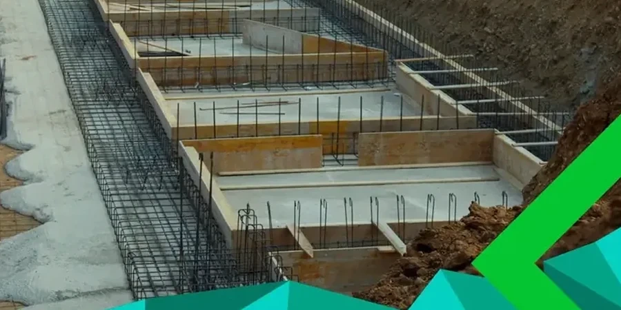
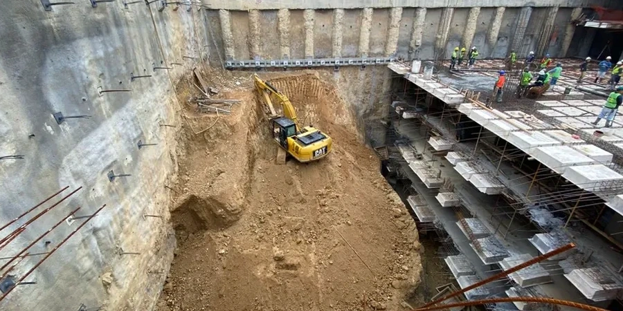
Victoria’s urban fabric is shaped by its deep harbor and glacial history, but the same geology that gave us the Inner Harbour’s strategic depth also creates complex excavation challenges. The city sits on a sequence of Vashon till, presorted marine silts, and the underlying metamorphic bedrock of the Wrangellia terrane. When you cut deeper than 4.5 meters in James Bay or downtown, you move from stiff clay into groundwater-fed gravels almost without warning. We have provided geotechnical design of deep excavations across the Capital Regional District, integrating local stratigraphy into every shoring calculation. Many projects in Victoria require a phased approach that combines a CPT test for continuous profiling with selective sampling, especially where artesian pressures are suspected near the harbor. The goal is a design that respects both the City of Victoria’s excavation permit requirements and the practical realities of working next to century-old masonry foundations.

In Victoria, the difference between a dry excavation and a costly delay is knowing exactly where the perched water table sits within the Vashon till sequence.

Our service areas

Methodology and scope

A common mistake we see on Victoria sites is assuming that a soldier pile and lagging wall designed for Vancouver conditions will perform identically here. It won’t. The glacial till in Victoria is often overconsolidated and contains cobble-sized clasts that can deflect drilling equipment and create gaps behind the lagging if the design does not account for localized overbreak. Our geotechnical design of deep excavations starts with a detailed assessment of the till matrix, its dilatant behavior during unloading, and the perched groundwater tables that form above the till-bedrock interface. We model the sequential excavation stages and specify tieback anchors or internal bracing accordingly. For excavations in the Fairfield and Rockland neighborhoods, where rockhead rises to within 2 meters of the surface, we often recommend line drilling or controlled blasting parameters as part of the shoring package. Complementing the design with a slope stability analysis is essential when the cut transitions into a permanent slope at the property boundary, ensuring long-term stability under saturated conditions.
Geotechnical Design of Deep Excavations in Victoria, BC
Technical reference — Victoria BC

Local geotechnical context

In Victoria, we often observe that groundwater drawdown triggers settlement in the sensitive marine clays underlying the till in low-lying areas like Vic West. A deep excavation design that focuses solely on wall stability without modeling the radius of influence of dewatering wells can cause damage to adjacent properties a block away. We routinely run coupled seepage-stress analyses to predict the consolidation settlement induced by pumping. Another local risk is the encounter with buried stream channels—now invisible—that cut through the till and are filled with loose, saturated alluvium. If a shoring wall intercepts one of these paleochannels without prior detection through a seismic refraction survey, the resulting inflow can erode the passive zone and lead to a sudden loss of toe support. We address these risks upfront in the geotechnical design of deep excavations by specifying contingency grouting and real-time piezometer monitoring from the first cut.

Need a geotechnical assessment?

Reply within 24h.

Email: [email protected]

Explanatory video

Regulatory framework

NBCC 2020 (National Building Code of Canada, seismic provisions for Victoria), CSA A23.3:19 (Design of concrete structures, anchors and reinforced shotcrete facing), CSA S6:19 Canadian Highway Bridge Design Code (CHBDC) for temporary works, CFEM (Canadian Foundation Engineering Manual, 4th Edition), ASTM D2487/D2488 (Unified Soil Classification System, USCS)

Typical values

ParameterTypical value
Design ApproachLimit Equilibrium (LEM) and Finite Element (FEM)
Typical Shoring SystemsSoldier pile, secant pile, diaphragm wall, soil nailing
Groundwater ControlDeep wells, wellpoints, ejector systems, cutoff walls
Seismic Load CaseNBCC 2020 Victoria seismic hazard (Sa 0.2 = 0.61g, Site Class C/D)
Deformation AnalysisLateral wall deflection, surface settlement trough, building damage assessment
Rock ExcavationRipability assessment, line drilling, controlled blasting where required
Material ModelsHardening Soil, Mohr-Coulomb with dilation, Hoek-Brown for bedrock

Questions and answers

What is the typical cost range for a geotechnical excavation design in Victoria?

Fees generally range from CA$2,600 for a straightforward single-family lot excavation with standard soil conditions to CA$13,010 for a complex multi-level basement or underground parkade requiring detailed FEM analysis, tieback design, and a comprehensive dewatering strategy. The final cost depends on the excavation depth, proximity to neighboring structures, and the level of instrumentation specified.

How do you address the risk of damaging adjacent heritage buildings in downtown Victoria?

We conduct a pre-construction condition survey and define strict settlement and vibration criteria. The shoring design incorporates stiffer wall sections—often secant piles—and limits the unsupported span. Our analysis includes a building damage assessment using the Boscardin and Cording method, relating angular distortion and horizontal strain to predicted damage categories, and we specify compensation grouting if predicted movements exceed 10 mm.

How does the seismic environment in Victoria affect deep excavation design?

Victoria lies in a high seismic hazard zone, with a 2% in 50-year ground motion (Sa 0.2) of 0.61g on Site Class C. Our designs incorporate the NBCC 2020 seismic load combinations, including the inertial effects of the retained soil mass and hydrodynamic pressures from groundwater. We use the Mononobe-Okabe method for pseudo-static analysis and verify performance under the design earthquake using time-history analysis where the excavation is adjacent to critical infrastructure.

What information do you need to start the design of a deep excavation in Victoria?

We start with a thorough geotechnical site investigation: continuous core sampling through the Vashon till and into the bedrock, CPT soundings to identify thin sand lenses, and installation of monitoring wells to map the perched and regional groundwater levels. Topographic survey, utility locations, and structural drawings of adjacent foundations are also required. With this dataset, we can develop a calibrated ground model and begin the shoring analysis.

Location and service area

We serve projects in Victoria BC and surrounding areas.

View larger map